|
LAND CONSERVATION
|
 |
ENVIRONMENTAL JUSTICE
|
|
LAND CONSERVATION
|
|
ENVIRONMENTAL JUSTICE
|
| MY FEE | MY RESUME | CONTACT ME |
|
|
Allen S. Hubbard, P.G., Geologist
2607 Toddville Road
Charlotte, NC 28214
704-393-9141
westside_al@msn.com
- A PERSONAL INTRODUCTION
I am a licensed professional geologist with over 35 years of experience. This includes 20 years of petroleum exploration in the Louisiana Gulf Coast area and ten years of environmental consulting in the Carolinas. I am available for consultation on various projects where geological input is required. My areas of expertise include environmental site assessments, wetland evaluation, underground storage tanks, oil and gas prospect evaluation, and petroleum exploration.Professional Affiliations: American Association of Petroleum Geologists (35 years), Union of Concerned Scientists, Carolina Geological Society, Sigma Gamma Epsilon, American Institute of Professional Geologists, American Association for the Advancement of Science, Environmental Site Assessment Society of America (certified environmental inspector).
- Licenses: licensed in North Carolina; license pending in South Carolina.
- Current Project: developing a roadside geological guidebook of North Carolina for the non geologist.
Educational Background:BA in geology Colby College, Waterville, Maine, 1963
Graduate work in geology at VPI (currently Virginia Tech), Blacksburg, VA, 1963-1964
and Tulane University, New Orleans, LA, All requirements for MS in geology except for successful thesis defense.
PETROLEUM GEOLOGY
- My fee is $500.00 per day plus expenses. Fee reductions are negotiable for long-term projects.
1965-1968: New Orleans, LA. I began my working career with two major oil companies Humble Oil and Refining Company (now Exxon) and Continental Oil Company (Conoco) in onshore and offshore exploration geology. During this time I attended Tulane University pursuing a Masters Degree in Geology. My thesis study, conducted while an employee of the U.S. Army Corps of Engineers, was on fluvial and lacustrine sedimentation in the Atchafalaya Basin.1968-1985: Lafayette LA. I worked as a petroleum exploration geologist for various independent petroleum producing companies and some of the time as an independent consultant on retainer. During this time I was fortunate enough to make several important discoveries, one of which, the Bayou Sherman field in Assumption Parish, has over 40 bcf of gas and 20 mmbbl of distillate. I was forced to leave Lafayette in 1985, as were many other oil people, with the decline of the domestic oil industry. A number of factors contributed to this decline, the chief factor being the flooding of the market by OPEC nations which greatly reduced the price of a barrel of crude, the tightening of tax laws regarding intangible drilling costs, and the phasing out of the depletion allowance, which adversely affected intangible (i.e. drilling) costs.
1985 present: Charlotte, NC. I was now part of the oil field diaspora and was forced to-re invent my career. I returned to school, (University of North Carolina at Charlotte). In order to obtain a master's degree in geography and get into urban planning. This did not work out, but I did learn enough about N.C. geology to pass his NC licensing exam and begin a consulting career. During this time I worked for three environmental consulting firms doing soil and groundwater cleanup, usually from underground storage tank releases.
- SOILS
I have also been a soil consultant for several area developers. These developers buy large tracts of land and retain me to examine soil borings to locate areas of suitable soil for septic systems. When the good soils are found, the lots can be laid out incorporating these soils. There are many areas in the southern Piedmont where soils are unsuitable for septic systems. These are soils that result from the weathering of quartz poor basic igneous rocks. Some of these soils consist of virtually 100 percent swelling clay and thus, drain very slowly. Some of these are soils that still have water standing on them a week after a rain.
- LANDSCAPE CONSERVATION
In an area of moderate to low relief such as the Southern Piedmont, chemical weathering has far outstripped physical erosion in shaping the topography. This chemical weathering has been going on uninterrupted for at least 50 million years while the soil profile has developed in response to a woodland environment. Over the last 200 years we have changed all that by agriculture and construction, so that very little of the original soil profiles are left. The ones that are left are found in the small pockets of old growth bottom lands that dot the landscape. In the next 20 years, even these small pockets will be gone if developers continue to have their way. Many of these tracts are privately owned and are being sold off to developers. Even though they are few and not very extensive, they deserve to be preserved because they have great educational and aesthetic value and, just as importantly, they're unrenewable. We have to get off the notion that the highest and best use for land is human occupation. Charlotte has the drainage problems it does because developers have been calling the shots for too long and, with the city's blessing, have been paving over every possible square inch of land. The soils that haven't been paved, have been chewed by the bulldozer's teeth and are rapidly eroding.
Not living on the country club side of town, and in a state and community whose officials drop their pants for any fly-by night industry that wants to set up shop, a personal instinct for survival has necessitated the pursuit of environmental justice. Thus, I have spent considerable time helping neighborhood groups understand what is being done to them.ENVIRONMENTAL JUSTICE
We live in a part of Charlotte that has had less than its share of municipal parks and more than its share of industrial parks. While residents of Myers Park and Eastover are home enjoying a warm fire and a martini, Westside citizens are often found at Council or Commission meetings vigorously protesting the latest environmental slap in the face that the city's "fathers" hand us with seeming impunity. These include but are not limited to: adding another runway to the airport, misuse of federal residential soundproofing funds, placing rock quarries in residential neighborhoods, renewal of NPDES permits that have been routinely abused by Paw Creek oil companies, NCDEHNR's refusal to put the blame for solvents in our well water where it belongs; to those very same oil companies. The list of outrages goes on and on.
- RISK ANALYSIS FRAMEWORK
Next to global warming and weather pattern changes, the biggest environmental problems this nation will have to face in the first half of the 21st Century will be the decline in overall water quality and the increasing scarcity of uncontaminated fresh water. Surface water quality is being compromised every time a reservoir is treated as a recreational area. Now, groundwater quality is being compromised by the adoption of the RAF or Risk Analysis Framework for soil and groundwater remediation.The RAF is a three tiered approach to environmental clean-up based on three scenarios of human exposure to groundwater ("G") and soil ("S") contaminants: G-1 is exposure via ingestion (drinking water, irrigation, swimming pools, etc.). G-2 is exposure via inhalation (vapors in basements or other closed spaces). G-3 is exposure via absorption from surface water ( ponds, streams, etc.). Tier G-1 requires groundwater cleanup to NCAC 2L (drinking water) standards; tier G-2 permits groundwater clean-up to a less stringent standard depending upon the chemical and physical properties of the individual contaminant; Tier G-3 allows for the least stringent standards of all, which can be up to 1,000 times the 2L standard.
S-1 is residential exposure to soil contaminants. S-2 is industrial exposure to soil contaminants. S-3 is exposure of soil contaminants to groundwater. The S-3 scenario is subdivided into three categories, depending upon the groundwater class as shown above, that the soil contaminants may impact: (e.g. S-3:G-1, S-3:G-2, and S-3:G-3). Each tier of exposure requires a successively lower clean-up standard for both soil and groundwater. If no risk of human exposure through any of the above scenarios can be demonstrated, the RAF will permit contaminant concentrations of 1,000 times the drinking water standard or 50 percent of the aqueous solubility of the compound, whichever is lower. In my years of consulting experience I have rarely seen a site so heavily contaminated.
The RAF will adversely affect various parts of the state in different ways: For example, a major chemical corporation could purchase a large tract of land in a rural area where none of the above scenarios apply and go about seriously contaminating the site without the consequences of being forced to clean it up. Many inner city industrial areas are more than 1,000 feet from a water well or surface water. These areas can likewise become contaminated or, if presently contaminated, remain so. Many lower and middle income areas of Charlotte and other large industrial cities in the state have I-2 tracts interspersed with residential areas. As the industrial areas become increasingly contaminated, the neighborhoods will suffer environmental decline.
The proposed RAF gives Industries virtual carte blanche to further contaminate their sites if they fit within the guidelines. Furthermore, areas that are zoned I-2 (heavy industry) that are presently undeveloped and pristine will certainly become contaminated in the future. In West Charlotte there is a considerable amount of presently undeveloped property which is zoned I-2. These parcels are in close proximity to residential areas. Many of these residences are served by private water wells. Indeed, according to the 1990 U.S. census there are 6,093 households within the city limits of Charlotte, the biggest and most industrialized city in North Carolina, that obtain their water supplies from privately owned wells. It is insult enough to the neighborhoods of West Charlotte to engage in such destructive zoning practices, but to deliberately allow these tracts to become polluted is an absolute crime.
Groundwater has traditionally been regarded as a natural resource with intrinsic value and deserves to be protected as such. The RAF is apparently driven by the concept that groundwater can be safely contaminated as long as it doesn't come into contact with humans via ingestion, inhalation, or absorption. Clean groundwater should be treasured. At the rate we are giving in to watershed development pressure and compromising the quality of our surface water supplies, it is only a matter of time before we will be forced to turn to groundwater as a major source. The highest and best use of groundwater is as a source of drinking water, not as a cesspool for industrial contaminants.
The RAF does not fully address the problem of chlorinated solvents, the most common contaminants found in well water. travel for great distances and impact water wells that are miles from the source. The RAF is based primarily on scenarios affecting horizontal contaminant migration through the surface aquifer. The vast majority of residential water wells are cased well into the bedrock and below the surface aquifer so they will rarely be impacted by surface aquifer contaminants. These contaminants will generally biodegrade in the presence of dissolved oxygen over a period of several years.
Of all groundwater contaminants, chlorinated solvents pose the biggest threat to groundwater quality. These compounds are widely used as de-greasers, solvents, and in the manufacturing process in many industrial activities. The most commonly used of these solvents is trichloroethylene (TCE), tetrachloroethylene (PCE), and 1,1,1-Trichloroethane. These chemicals are strongly carcinogenic and are defined as priority toxic pollutants by the EPA. They are heavier than water and can sink through the aquifer and travel considerable distances through the joints, or cracks, in the bedrock. These contaminants are virtually impossible to remove by conventional pump and treat methods and break down very slowly.
There is already widespread contamination of water wells by chlorinated solvents in the Paw Creek area of West Charlotte. Contaminated wells are found as far as one half mile from the nearest possible source. 101 wells were found to be contaminated with solvents, nine of which had concentrations above the 2L (drinking water) standard. It is important to remember that 2L standards are based on ingestion (drinking). When the water is heated and the vapors inhaled, it is like getting three times the ingested concentration because the contaminants go straight to the blood stream. There have been many reported fatal cases of cancer and leukemia from the Paw Creek area where there have been on-going epidemiological studies. In the 1970s The town of Woburn, Massachusetts, experienced severe TCE contamination of two of its municipal water wells by two industries resulting in twelve fatal leukemia cases in a single neighborhood before the wells were closed.
Many of the polluting activities carried on in the past were not illegal at the time and we are now being forced to live with the results of our past ignorance of environmental hazards. Human (and corporate) nature being what it is, corporations will only respond to regulations that hit them hard in the pocketbook. Under the present regulatory requirements, forcing the clean up of contaminated sites to drinking water standards, industries have been compelled to exercise responsible housekeeping practices. When these requirements are relaxed, the State of North Carolina will have taken a giant step backward in the regulation of environmental quality. Under the existing regulations, neighborhood groups in West Charlotte have continually had to force state and county environmental agencies to do their job in confronting polluting industries at Paw Creek and elsewhere. Under the RAF what marginal environmental protection we get now will disappear entirely.
Once these presently pristine industrial sites become contaminated, they will need to be burdened by deed restrictions to limit future use. At the present time, the State cannot enforce deed restrictions. These can only be agreed upon by buyer and seller. Therefore, there is no guarantee that future use of industrial sites will not result in human exposure to contaminants unless laws are passed allowing the state to control the use of property. In my opinion, the state of North Carolina has no business being involved in private property transactions.
Let's follow the money trail and see where it leads: the only people to benefit from this are the banks, the developers, and industry. The banks benefit because they will be able to finance loans on contaminated property without the fear of being stuck with the clean-up cost if they are forced to foreclose. As a matter of fact the banks are already initiating foreclosures on contaminated sites. Developers benefit because they can develop hitherto unusable sites which are in prime locations. These include several contaminated sites in uptown Charlotte that the banks and developers want to use for the proposed sports and entertainment district. Industry benefits by avoiding clean-up of many contaminated sites. Furthermore, industries will be able to contaminate a pristine site within the guidelines of a site specific risk analysis.
The only people who will benefit are the economically privileged and politically connected. Very few, if any, of whom live in West Charlotte. The people who will be negatively impacted are the lower and middle income citizens who live in West Charlotte and other areas that have already received more than their share of environmental insult. I attended the DEHNR public meeting in Raleigh on February 11th and made these comments to the panel. It appears that adoption of the RAF is a done deal. If the RAF is adopted, it has to be with safeguards to protect highly industrialized lower and middle income areas from further environmental degradation.
1. Strict regulations regarding the transport, storage, use, and disposal of chlorinated solvents, RCRA metals, and pesticides.These sites are, for the most part, owned by major corporate entities who have more than enough resources to clean up their contamination. If they won't, padlock them until they do. Residents of North Carolina have a right to clean water and air. Since environmental leadership in North Carolina is not originating at the top, it will have to start from the bottom. There is a ground swell of awareness among poorer neighborhoods throughout the state of the environmental injustice they have been forced to endure.
2. Restriction of property use in residential neighborhoods to non-polluting industries.
3. Full clean-up and restoration of contaminated sites within urban areas to prevent neighborhood decline.
4. Close inspection and monitoring of industrial practices to avoid future contamination.All of this about the RAF is symptomatic of what is wrong with most of the environmental regulatory community not only in North Carolina but in most of the US as well. For too long we have based our regulations on individual compliance rather than looking at the big picture. We now have a situation where all of the polluters are in "compliance", but our water and air are contaminated. Many state and county environmental agencies are deliberately under funded so that they will not have neither the manpower nor the facilities to adequately sample air and water emissions. Since they cannot monitor these industries, they simply ask them how much of each contaminant does their manufacturing process generate and permit them for those amounts. Under these circumstances, the industries have little or no incentive to make any effort to reduce their waste streams. As more industries are added to a growing metropolitan area, the environmental situation becomes worse.
Air and water quality will continue to get worse unless active measures are taken to clean up air and water by making industries reduce their emissions. This has been accomplished with great success in the remediation of Lake Erie and the Hudson River. New York City's air quality has been improved by the reduction emissions from coal fired electrical plants. In Los Angeles air quality has been improved by the use of cleaner burning fuel.
Meanwhile, Charlotte spends a majority of its days at levels of code orange or worse. And its not even summer.
- MICROLIMATES
Microclimates are important in the South and even more so in mountainous areas. Radiant heat plays an important part in governing local climate, especially in winter. A patch of ground facing south may be warm to the touch and bare of snow, while other areas may still be covered with several inches of powder, indicating that the air temperature has not risen above freezing. Valleys that have southern exposure enable people to live at elevations that would normally be extremely inhospitable in winter.The amount of sunlight falling on a given area of ground is directly proportional to the sine of the sun's angle. If the sun is directly overhead, its angle with the ground is 90 degrees. The sine of 90 is 1. Therefore, the ground is receiving 100 percent of the available solar radiation. If the sun is at an angle of 45 degrees the ground will receive approximately 71 percent, at 30 degrees 50 percent, and so forth. If one were to make a table showing these relationships from 10 degrees to 90 degrees an interesting relationship emerges.
As the sun's angle increases its sine approaches unity. When the sun's angle is 90o, sun directly overhead, the sine value (O/H) is 1 and the ground is receiving 100 percent of the available sunlight. As the sun's angle decreases, O/H becomes less until the angle reaches 0 degrees, sun on horizon, the sine is also zero and the ground is receiving no effective radiation. , e.g., the sun is overhead, the sine value is 1 meaning that the ground is getting 100% of the available sunlight
ANGLE SINE SINE X 100 CHANGE SEASON
90 1 100% 0
80 0.98 98% 2 Summer
70 0.94 94% 4
60 0.87 87% 6 Fall &
50 0.77 77% 10 Spring
40 0.64 64% 13
30 0.50 50% 14 Winter
20 0.34 34% 16
10 0.17 17% 17
It can be seen from this chart that when the solar angle is higher, as in the Summer, a ten percent change in solar angle doesn't mean as much as it does in the Winter when the solar angle is lower.North Carolina averages 36 degrees north latitude. On the shortest day of the year, the sun is at 90 degrees over the Tropic of Capricorn at 23.5 degrees south latitude. Subtract 23.5 (degrees of latitude north to the equator) and 36.0 (degrees of latitude from the equator to Roan Valley and you get the value of 30.5 degrees which is the solar angle at noon on the 36th parallel. Referring to the table above, a horizontal land surface is receiving approximately half the sun's output. By the same token, a land surface sloping ten degrees south would receive the amount of sunlight as if the sun were at an angle of 40 degrees, or 64 percent. Land sloping 10 degrees north would receive sunlight at an angle of 20 degrees or only 34 percent of maximum. Thus, at this latitude, at this time of year, a 20 degree decrease in solar angle results in a 47 percent decrease in sunlight.
On the longest day of the year, the sun is directly over the Tropic of Cancer at 23.5 degrees north latitude. This time, to get the solar angle at 36 degrees north latitude simply subtract 23.5 from 36 which gives 12.5. Subtracting 12.5 from 90 gives 77.5
The sine of 77.5 degrees is 0.976, which means that a horizontal surface at 36 degrees north latitude receives 97.6 percent of maximum sunlight. The piece of ground sloping away from the sun is now getting 92.3 percent and the land sloping 10 degrees toward the sun gets very close to 100 percent of the maximum available sunlight. In the Summer, there is less than an eight percent difference between the sunlight received by the plots facing toward the sun and away from the sun. This relationship also explains why there is a greater temperature gradient between the northern and southern United States in the winter than in the Summer. More about this later.
- THE APPALACHIANS (from a draft of: A North Carolina Roadside Geology Book)
Although the Appalachian Mountains are considered to be an old range compared to the Western ranges, the actual mountains that we are now seeing are not geologically very old at all. They are the result of several very recent episodes of regional uplift over the last few million years These periods of uplift were relatively short alternating with longer periods of weathering and erosion. The Blue Ridge scarp is also a relatively new feature. It formerly extended much farther east than at present. The South Mountains are an outlying remnant the Blue Ridge, now detached from it by several miles. The Eastern Continental Divide runs along the crest of the Blue Ridge: a drop of water falling east of the Blue Ridge flows to the Atlantic Ocean while water falling on the western side will flow into the Tennessee, Ohio, and Mississippi Rivers and ultimately into the Gulf of Mexico. It is quite clear that a stream that only has to flow a few hundred miles to reach sea level at the Atlantic Ocean will have much more erosive power than a stream which has to flow two thousand miles to the Gulf.The original Appalachians were formed at various times from middle to the end of the Paleozoic era, the Northern Appalachians being formed during the middle Paleozoic and the Southern mountains later in the era. According to plate theory the earth's crust is not one solid sheet, but consists of a number of plates which move about over the earth's steered by convection currents deep within the earth's underlying mantle. The plate boundaries are either rifting and creating new crust such as along the mid Atlantic ridge, sliding past each other as along the San Andreas and other faults in California, or converging as is presently occurring in the Himalayas, Alps, Andes, and other young mountain chains. Mountains are formed when one plate is shoved under a neighboring plate creating a double thickness of crust. The Himalayas are presently being formed by the collision of the Indian plate with the Eurasian plate. Although the Himalayas are the highest mountains presently on earth, they are still rising.
Plate 1. Geologic time scale. Notice that Pre Cambrian time era is five times as long as all the subsequent periods combined. The column on the right shows the North Carolina rocks represented from the various time periods.
INSERT
The Appalachians were created by the collision of the African and European plates with the North American plate. This collision shoved the African plate beneath the North American plate, compressing and thickening the continental crust by several scores of miles and squeezing the crust upward and downward like toothpaste. The original mountains formed by this collision may not have been as high as the present day Himalayas, but they were probably at least three times as high as they are now. The original Appalachians were greatly reduced by erosion and weathering processes before the end of the Mesozoic era. However, since there was still excess underlying crustal material from the plate collision and because continental crust is lighter than the underlying oceanic crust and mantle, the region continued to rise, not due to compression or organic forces, as was the original cause of uplift, but by broad, regional epeirogenic forces, floating up like an iceberg as the exposed tip melts. This type of uplift is termed rejuvenation because, as the elevation is increased stream energy and erosional activity is increased. These intervals of uplift were episodic, with shorter periods of uplift alternating with longer quiet periods of weathering and erosion. Erosion was not necessarily carried to completion during these quiet periods, but relief was significantly reduced. Weathering and erosion appear to be extremely slow processes to our eyes, but enough time has passed since the formation of the original Appalachians for several miles of rock to be removed.
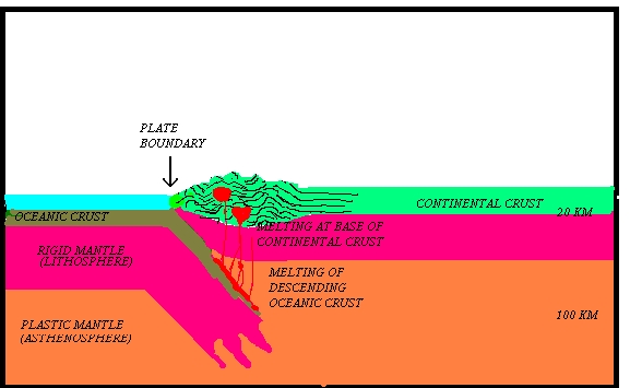
Plate 2. The subducting plate (left) dives beneath the over riding plate (right) and shoves the crustal material up in bulldozer fashion. The crustal material in the subducting plate is carried downward and at depth begins to melt. The molten crust rises, mixes with molten rock at the base of the continental crust and forms granitic rock.
The rate of erosion slows down as relief is reduced so that it requires a considerable length of time to proceed to completion. When relief (or steepness) of the mountains is reduced to a point where soil and vegetation can form on the slopes, erosion proceeds at a much slower rate. In fact at this point erosion takes a back seat to the process of chemical weathering, in which rock is slowly turned into soil. Some very thick clay deposits have already formed in the Appalachians. The Spruce Pine mining district is known for its thick deposits of kaolin which are used by the ceramic industry. More about this later.
- PLATE THEORY
The development of the theory of plate tectonics was to historical geology what the concept of a heliocentric solar system was to astronomy. It totally revised the way geologists thought about the development of the earth's features. Early astronomers developed complicated laws to explain planetary motion in an earth centered solar system which became irrelevant in a sun centered solar system. Likewise, early geologists developed many theories to explain mountain building, none of which was entirely satisfactory. No mechanism could be developed to fully explain the huge compressional forces that were necessary to move large pieces of crust great distances, subsequently pushing them up to such high elevations. Also, geologists were hard pressed to explain the presence of plant fossils in northern latitudes, where plants do not now exist. Equally puzzling was the presence of glacial material in areas that are presently tropical. The best theory they could posit was that the north and south poles had wandered all over the earth's surface in the geologic past. Paleontologists were long puzzled as to why the Paleozoic fossils in eastern North America are more similar to those in Europe than to those in central and western North America. They hypothesized that a mountain range must have run north and south through the middle of North America.Prior to the development of plate theory, geologists, along with anyone else who ever looked at a globe, had long noticed how the coastlines of Africa and South America were mirror images. But, without a theory to explain the mechanism that caused the continents to separate, it was nothing more than an interesting observation. Some geologists at the time did believe that the continents slowly moved about the earth's surface creating and destroying ocean basins. However, they had no model to explain the theory and were ridiculed by others as radical.
For many years information about the history of deep sea basins could not be gathered. However, techniques were developed in the 1960's which made deep-sea coring possible. The first ship equipped with deep ocean drilling equipment was the Global Marine Drilling Company research vessel Glomar Challenger. As little as thirty years ago it was presumed that the deep sea beds had always existed, unchanged, in their present locations. Therefore, when the Glomar Challenger went to work in the North Atlantic basin, expecting to drill into extremely thick marine sediments that dated all the way back to early Pre-Cambrian time, long before the advent of life they instead drilled into oceanic basalt after encountering a relatively thin sedimentary section, containing fossils no older than Jurassic; the age of dinosaurs.
They also made another important discovery. When analyzing the basalt samples from the borings, they found that the polarity of the iron molecules had been reversed many times throughout the entire width of the ocean basin. This same pattern of reversals, positive-negative-positive, etc., was found in all of the east to west boring sections in both the North Atlantic and South Atlantic. Since this pattern was so widespread, it had to have been caused by an external force, supposed to be the periodic reversal of the earth's polarity. In other words, there must have been times in the earth's past when the south end of a compass needle would have pointed true north! The most important feature of these reversals of polarity is that they were mirror images of each other on either side of the Mid Atlantic Ridge. This indicated that molten magma was oozing out of the ridge and crystallizing according to the current polarity and spreading east and west across the Atlantic Ocean basin away from the Mid-Atlantic Ridge. The fact that the sea floor was spreading in this manner provided the mechanism by which the two continents might have first separated. That the variations in polarity are mirror images of each other on either side of the Mid Atlantic ridge indicates that oceanic crust is being manufactured at the Mid Atlantic ridge and is being pushed away as new crust takes its place. The speed with which the Atlantic sea floor is spreading away from the Mid Atlantic Ridge is estimated to be about two inches per year. This rate of speed would allow about 100 million years for the continents to have reached their present position.
Iceland is situated astride the mid Atlantic Ridge which explains its volcanism. Bermuda, the Azores, the Canaries, and other islands in the Atlantic are built on the bases of old volcanoes originating along the Mid Atlantic Ridge. More about this later.
|
|
|
| Union of Concerned Scientists |
|---|
|
|
| The GeoCouncil |
| More Geology Links |
| Search The Web For Geological Points of Interest With LYCOS |
Reproduction of this site and its contents is encouraged.